
Muncie Neighbors by Source
No single roll identifies every person around a Muncie address. The county cadastral map shows parcel shapes. Beacon adds recorded ownership, tax mailing details, and the property location. Recorder instruments document title events. Indiana voter records follow a separate, regulated path, while community groups publish leaders rather than household rosters. The source table keeps those roles apart.
| Block source | Evidence it adds | How to reach it |
|---|---|---|
| Delaware County GIS | Adjacent parcel geometry, lots, subdivisions, STR labels | Public map; not a legal survey |
| Beacon and Assessor | Recorded owner, mailing and situs addresses, assessment | Parcel-by-parcel public search |
| Delaware County Recorder | Transfer chain and instruments for each lot | Online index from 1982; older-record fallback |
| Voter reports | Eligible precinct or address-oriented lists | Request and use limits; no street browser |
| Muncie Neighborhoods | Neighborhood names, leaders, and program contacts | Public association pages; no member roster |
| Historical directories | Past occupants in street sections | Digitized 1876-1928; later physical holdings |
An owner name is not the same as an occupant name. Tax mail can go out of state, a trust can hold title, and a resident may not own the lot. A dated county sample makes that split plain by printing separate mailing and situs fields. Use those fields as clues, never as a shortcut to call someone a current neighbor.
Map a Muncie Neighbors Block
The Delaware County GIS viewer is the map-to-record step. Search or locate the target lot, stay at parcel scale, and inspect only the polygons that immediately adjoin it. The research did not confirm a buffer or radius control in the live viewer, so click each lot rather than promising an automated circle search.
- Normalize the full street address, including its directional, unit, and postal label.
- Identify the target parcel in GIS. Copy its parcel, lot, subdivision, STR, and legal labels.
- Click each adjoining lot polygon and open the related Beacon record where available.
- Compare owner, mailing address, situs address, and deed reference. Mark each field by role.
- Use Recorder dates for transfers, then check older directories only for past block context.
GIS lines are for orientation, not boundary disputes. A deed's legal description and a survey control those questions. When the task grows beyond the immediate lots, the Muncie street directory covers the full named-road chain.
Muncie Neighbors and Associations
Muncie Neighborhoods reports more than 50 identified neighborhoods and says 27 were meeting regularly in its 2025 material. Its public pages offer neighborhood names and leader routes, not lists of every member or address. That makes the network useful for community context, local programs, and the right public contact, but not for proving who lives on one block.
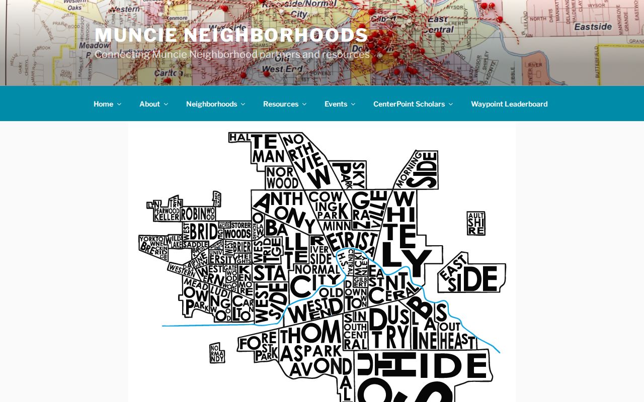
The captured association page shows the community-directory layer available to a Muncie neighbors search. It belongs beside parcel evidence, not in place of it.
| Association examples | Public route | What not to infer |
|---|---|---|
| East Central, Industry, Whitely | Muncie Neighborhoods leader list | No complete member roster |
| Old West End, Riverside/Normal City | Leader and program contacts | No legal boundary claim |
| Southside, Westridge, Westbrier | Neighborhood network pages | No household confirmation |
| Anthony Northside, Halteman Village | Dated 2025 leadership material | Contacts can change |
Muncie Neighbors and Voter Records
IndianaVoters cannot display every voter on a Muncie block. Its individual public check requires first name, last name, date of birth, and county of current registration. It returns an identity match or a not-found result. There is no verified public street browser.
Indiana law allows regulated voter-file and walking-list reports for eligible requests, with report type, geography, requestor category, use limits, and protected fields governing access. Safe at Home records are withheld. Names and addresses cannot be treated as a free list to scrape, sell, redistribute, or use for commercial solicitation. If the public form finds no one, check exact spelling and county, then contact Delaware County Voter Registration rather than guessing at dates.
Muncie Block Tools Compared
Official records and commercial neighbor tools serve different roles. County records identify the custodian, field, and record date. Commercial products may blend old filings and may not show which fact came from which office. Neither source should be read as a live household census.
| Source category | Strength | Main limit |
|---|---|---|
| GIS and Assessor | Parcel geometry and recorded owner fields | Does not list all occupants |
| Recorder | Dated title instruments and legal descriptions | A recording is not proof of present residence |
| Community association | Local names, leaders, and programs | No complete household roster located |
| Commercial category | May gather many sources | Age, origin, and accuracy may be unclear |
For civic curiosity, family research, or a property question, save the official citation and confirm it with the office that holds the record. A well-sourced result is more useful than a long list with no date.
Past Muncie Neighbors on Paper
Ball State's digitized Muncie directories cover 16 volumes from 1876 through 1928, with later physical holdings noted from 1929 onward. A street section can place past occupants on both sides of a block. Read the whole number range. A nearby name can reveal a changed street, a skipped number, or the line between a household and a business entry.
Address continuity is a special Muncie issue. The Uniform House Numbering System began with a December 1974 ordinance after nearly 60 percent of buildings were reported as wrongly posted. Work continued from 1975 through 1989. For pre-change neighbors, bridge the old and new number with the SC16 collection, legal description, plat, owner name, and a Sanborn sheet. Do not match on the number alone.
Muncie Neighbors Through Deeds
Recorder records add time to the parcel ring. Begin with the owner, legal description, deed reference, and parcel number shown for each adjoining lot. Search the current owner as a grantee around the apparent transfer date. The purchase instrument can identify the grantor, recording date, instrument type, prior reference, and the legal land description. A grantor is the party conveying an interest; a grantee receives it.
The Delaware County Recorder states that document indexes run from 1982 to the present and images from about 1982. Remote Laredo access requires a subscription, while Tapestry supports occasional paid searches. Older work can move to county books, microfilm, and Muncie Public Library's digitized deeds from 1827 through 1961. The exact online bridge for 1962 through 1981 was not verified, so ask the Recorder for the right index volume rather than treating the gap as a missing transfer.
Title must also be read by instrument type. A mortgage or release does not necessarily transfer ownership. Trusts, estates, banks, and combined tracts can appear in the chain. Match the legal description and associated documents before attaching a historical name to a modern block.
Record Muncie Neighbors Carefully
A small worksheet prevents field roles from being blurred. Write the address as USPS returns it, then record the parcel ID, legal description, situs, tax mailing address, recorded owner, deed reference, source date, and neighborhood label in separate columns. If a lot is vacant or carries more than one address, note that before comparing it with the lots next door.
- Parcel
- The county's mapped and assessed unit of land, identified by its parcel number.
- Situs address
- The physical location assigned to the property, distinct from the tax mailing address.
- Legal description
- The lot, tract, subdivision, or survey wording that identifies land in a recorded instrument.
- STR
- Section, township, and range references used to place land within the survey system.
Compare only like fields. A neighborhood name should be checked against a neighborhood map, while ownership should be checked against Beacon and the deed. This keeps the immediate Muncie neighbors workflow narrow, clear, and easy to update when a parcel changes hands.
Privacy for Muncie Neighbors
A parcel card does not list every person who stays at a property. Voter records omit protected addresses and do not cover every resident. Directories miss people who were not listed, and utility or delivery customer lists are not public. Indiana's Address Confidentiality Program, also called Safe at Home, gives eligible victims a substitute mailing address and shields voter information except for authorized access.
Lawful use. Research Muncie neighbors for a legitimate personal or civic reason. Never watch, harass, intimidate, or harm another person.
Indiana's Consumer Data Protection Act took effect January 1, 2026, but state and local government records are excluded. It does not erase a county parcel card or deed index. A missing address may be a legal safeguard, not a bad result. Respect the omission and ask only for public, redacted fields.
Muncie Neighbors Beyond Parcels
Some block questions need context instead of more names. ScoutMuncie uses a Delaware GIS-developed mobile app for a volunteer neighborhood and historic-resource survey, though no public person-level dataset was located. The Historic Preservation Commission covers districts and landmarks. Muncie Improvement Resolutions can connect a resident or group to a past street project.
For older photographs, organization files, oral histories, and local articles, the Muncie Public Library, Ball State Archives, and the appointment-only Delaware County Historical Society are the right human fallbacks. Their collections can explain how a block changed. They do not replace a current parcel record, certified deed, or official boundary.
Muncie Neighborhood Lines Differ
The official city neighborhood map and the broader Muncie Neighborhoods list are social and planning layers. They are not parcel boundaries. Names such as Downtown, East Central, Industry, Old West End, Whitely, Ball State, Riverside/Normal City, and Thomas Park-Avondale can help frame a local question, but a deed, precinct, ZIP, and city line may sort the same address in other ways.
This is a strong local comparison, not a flaw. Use an association label to find the community contact. Use GIS for parcel geometry. Use a city or county boundary source for jurisdiction. If two maps disagree, state which layer supplied each name rather than choosing the one that seems most familiar.
Note: A neighborhood contact list can explain programs and meetings, but it cannot establish who occupies any particular Muncie address.